|
In July, 2020, during the pandemic, we were able to go on a planned vacation in our trailer to the east side of the Sierras and more. Being in our trailer, we were physically distanced from just about everyone. We ate, showered, and slept in the trailer so we were not close to others except when we were walking on trails. We didn't go out to eat or go to shops except one gift shop that was open. Museums and visitor centers were closed so that distracted a little from our trip. We enjoyed seeing new parts of California and revisited some parts we had seen before. Most places we stayed allowed for campfires, so we had one every night except for one where they didn't permit them. We enjoyed our nightly s'mores. Well, actually, we found that we enjoy a toasted marshmallow in graham crackers, and no chocolate was needed. The orange line shows our path as captured by Amateur Radio APRS service and Google Earth. 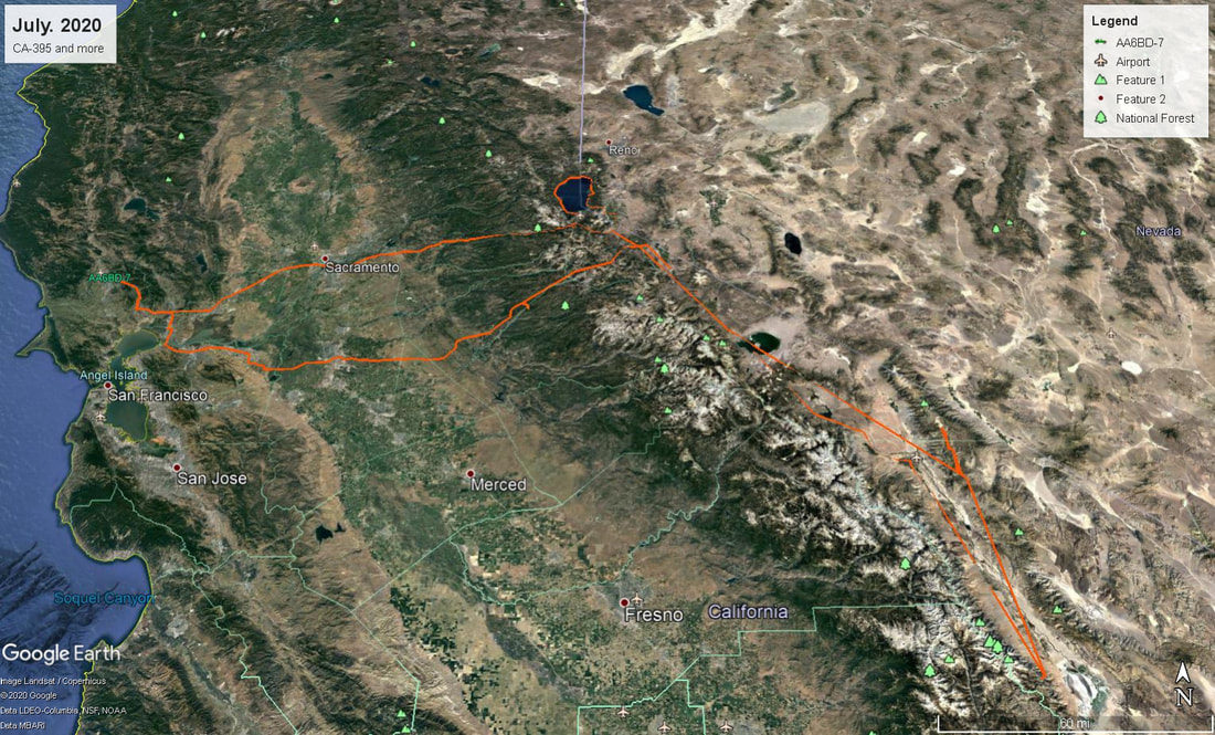
0 Comments
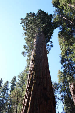 We left Mono Vista RV Park intending to drive up to Tioga Pass and through Yosemite to Calaveras Big Trees SP. We did drive up to Tioga Pass but found that even though it was a state route, CA 120, we were not allowed to enter Yosemite without a day pass as part of their COVID-19 protocols. They rangers told us that we were going out of our way and it would be shorter to take CA 4. So back down CA 120 we went to US 395. We went back up Monitor Pass at 8,314 feet on CA 89 and down the other side to the junction with CA 4. We started up and saw a sign that gave us pause. 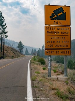 Where have you seen a road with 24% grade?? We stopped and had a break and talked about it. We looked at the map and the only other way to get there was to take either US 50 or CA 108 and it looked like about 4 times as far because of the over and back path to Calaveras Big Trees SP. We decided to go for it, and if the road was so steep, we could always put the Jeep in low 4WD to make it. We also knew that the east side would be steeper and I would rather go UP 24% than DOWN 24%. We emptied our fresh water tank to eliminate some weight. The road started out nice enough, and when we started climbing a little, it was still OK. Then we lost the center yellow line as the road narrowed. The steepest parts seemed to be on the hairpin turns. Well, you are going slow there anyway, right? Fortunately, we didn't meet any large vehicles coming toward us. We made it over the pass at 8.730 feet, and then had to go over the second pass, Pacific Grade summit at 8,050 feet. We drove by Alpine Lake, a gorgeous lake, and picked up the yellow line again, and went down the western side which was more gradual. For future reference, Sonora Pass was higher at 9,624 feet but a full two lanes the whole way. When we got to Calaveras Big Trees SP, we found that they had a fresh water fill right after the dump station, so we knew we could fill our fresh water tank and also dump before starting home. Unfortunately, when I tried to close the valve on the tank, the little plastic handle broke off. I managed to use pliers to get it mostly closed, and we put a piece of plastic wrap and a rubber band over the valve so it just dripped very slowly. We knew we could always return and get our tank filled again if needed. As it turned out, there was a water spigot in our campsite so we could have filled our tank there. Calaveras Big Trees SP is named for its groves of Sequoia trees. After we arrived, we walked through the North Grove campground to the boardwalk over the meadow in the middle of the campground. The next day, we hiked around the North Grove trail. They had marked it as one way to reduce chances of virus exposure. The grove was different from other Sequoia groves in that there was a mix of trees whereas other Sequoia groves were mostly Sequoias. It was a pleasant walk and most hikers wore masks - but not all. After walking the North Grove, we stopped at the visitor center and found that the center was closed except for the gift shop where they allowed only up to 10 people at a time inside. That worked for us and we got our usual decal to put in the trailer and our park t-shirts. We drove the Parkway that connected the north grove to the Stanislaus River and the south grove, which is much larger. It was a 5 mile hike so we decided to just walk the Beaver Creek trail which was much shorter. We walked to the creek which was pleasant with a number of people wading in the cool water. Then it was back to camp. We had no Verizon coverage but the park had Wi-Fi at the visitor center and our Wi-Fi booster gave us a good signal at our site. The Calaveras Big Trees SP was a great park to end our ten day trip across the Sierras and back. We went home by following CA 4 down the Sierras and through the Valley. It was a bit curvy and rough across the delta. It would have been better to take CA 49 and 16 to Sacramento and then take i-80 home although more miles but not necessarily more time. 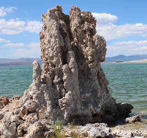 Our original plan was to go south from Lone Pine to Red Rock Canyon State Park but it was just too hot, and we realized that we would have a long drive from there to our next campground at Calaveras Big Trees State Park. We had passed what looked like a nice RV park in Lee Vining, so we called and got a site at Mono Vista RV Park for one night. We spent time traveling down to the edge of Mono Lake. It is a large lake that is in the Great Basin, so the water flows in but not out of the lake. Years ago, Los Angeles got water rights and diverted the streams that fed the lake and it began drying up. After court fights, they agreed to restore some flow so that the lake would not dry up but would not be restored to its level before they started diverting the water. Because of the geology of the lake, there are large formations that appear to have grown out of the lake. Actually, they used to be underwater and have gotten exposed as the lake level has lowered. These Tufas are interesting to see and walk around and through. They remind me of stalagmites without the matching stalactites you see in many caves. They are made of similar minerals, calcium carbonate. They are formed as the minerals bubble up from below the lake. The lake is where many gulls and other birds winter and make their nests. We walked the path to the Tufas and along the shore of Mono Lake, and then back to the parking area. Nearby, there is the Panum Crater, which is a large cinder cone that you can walk up to and around. We decided it was too hot to actually walk up the side of the crater so we just observed it from the base. There are a series of craters so this are is obviously volcanically active. We moved the trailer to Mono Vista RV Park which was very nice, with big trees and some grass. It was great for one night except for one thing: other campers. We were close to our neighbors and two large Class B RVs pulled in behind us, as we were in back-in sites where we were back to back with the sites behind us. Out got two families with small children. Maybe it has just been too long, but I don't remember our kids being that unruly. And I think we did a better job of keeping the lid on our kids' exuberance. We saw that they were preparing dinner in the space between their two RVs. Jennifer went out of the trailer a little later to discover that they had gone off somewhere and just left their dinners sitting on the picnic tables. And seagulls had discovered them. She chased off the birds, and we spent the next half hour taking turns chasing the seagulls from the dinners left on the tables. After a while, the families returned and we told them what had happened, and they didn't seem that annoyed to us. We would have been very concerned, but they didn't seem so. I am glad I have more training and sense than they did. 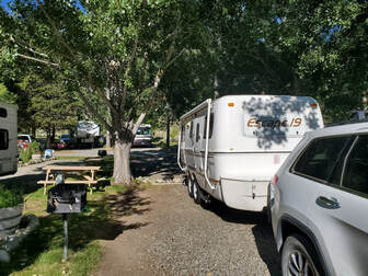 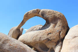 While we were camped at Lone Pine, we had hoped to visit some museums and places, but all indoor places were closed to protect against virus infections. We had hoped to see Manzanar again, but all indoor facilities were closed, as were the Eastern Sierra Museum and the Museum of Western Film History. Alabama Hills BLM was open as it, of course, is all outside. So that is where we headed. It is just west of Lone Pine. Alabama Hills has been the scene of many western movies so we hoped to see some interesting terrain. And we did. Shortly after starting on the Movie Road, we saw a turnoff to the Lone Ranger Canyon, so off we went. This part of the Hills is a series of dirt roads through the sand and rocks. After going just a short way, I became concerned that we might never find our way out. Not really, as the GPS was showing us where we were, but still, it was a bit unnerving to me. After we went over a rock and down into another canyon area, I felt we should go back. While going over the rock in our 4 wheel Drive Jeep, I realized that I could not see if anyone was coming toward me and the road was barely a lane wide there. So we turned around while I still had a sense of where we were. Jenn got out and walked to the top of the rise to be sure no one was going to meet us at the peak. I put the Jeep in low 4WD mode and up I went. It's good I was in $WD because the sand caused me to slip a bit on the way over the rise but I made it to the top easily and stopped to pick up Jennifer. And back we went the way we had come, and then stuck to Movie Road. The scenery was quite nice as you can see from the slideshow. We had the Alabama Hills around us and Mount Whitney and more of the Sierras just behind the Hills. We found the parking space for the hike to Mobius Arch so we stopped and started walking to te arch. The trail was fairly well marked. That is to say, it was not well marked. But we found our way around some rocks, and there was Mobius Arch. Since it was quite hot already, we chose to return the 1/4 mile to the Jeep rather than hiking the 3/4 miles around the loop. After returning to the Jeep, we saw another Jeep towing a trailer on around the road, along with a variety of other high and low clearance vehicles. Shortly after that, we saw some cars moving slowly and going on our side of the road for a bit. We found why: there was a short section of the road with a lot of the sand mounded on the other side of the road, and when we saw a jeep with large tires go through it, we saw how much up and down was involved and why other cars were avoiding it. It was bad enough on our side of the road, which I am sure was better because we were going downhill in that section. It reminded me of parts of the road in Monument Valley. Around the bend, there was the family with the trailer setting up camp in a boondocking spot. It was really hot, and we could see he was also starting up his generator, presumably for running his air conditioner. He would need it! We continued around Movie Road and out of Alabama Hills and managed to find our way onto Moffit Ranch Road and back to US 395, and then back to camp. I took more photos of the Sierras than of the Alabama Hills. Too bad. Next time, more photos of the Hills! 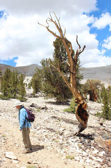 This is not to be missed. We saw the oldest trees on the planet. They grow only at selected high elevations because they don't compete well with other trees. But because of this location, they grow very slowly. Scientists count the rings and have determined that the trees are thousands of years old. They have used the ring spacing pattern to date the trees and other trees in Native American reservations, and to confirm carbon dating. Yes, they are that old. We first stopped at the visitor center which was closed due to COVID-19 but since we had been there before, we knew what to expect. The information signs are excellent. The visitor center is at the end of a paved road at 9,846 feet elevation. We walked the one mile Discovery Trail, which took us past Bristlecone Pine and Limber Pine, the only trees to grow here. We then drove up the dirt road another 13 miles to the Patriarch Grove at 11,300 feet elevation. The Patriarch Tree is the largest Bristlecone Pine tree. We walked the trail past this tree and many others in the area. It is quite a sight to see these very old trees. On the road to the Schulman visitor center, there is a viewpoint that provides a stunning view of the Sierra Nevada mountain chain. And we learned that we can see much the same view from spots along the road. We didn't see this on the way up the road as we were looking the wrong direction, but we couldn't miss the view when driving back down the road. 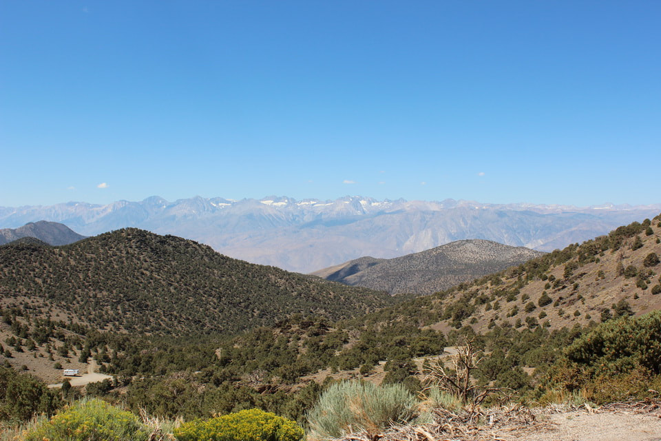 Today, we drove from June Lake to Lone Pine, where we stayed at Boulder Creek RV Resort. When we arrived, we wondered what to do this day as we were planning to spend the next day going to Ancient Bristlecone Pines NF. We noticed on the RV park information that there were two roads up to the Sierras from Lone Pine. We took the first, which led to Whitney Portal. We knew nothing about it other than we were driving toward Mt Whitney. So up we drove to about 8,374 feet elevation from our camp at 3.727 feet so it was up, up, up. The road was good so no worries there and we weren't pulling the trailer. Whitney Portal is the trail head for the eastern approach to Mount Whitney, which is at 14,505 feet so quite a bit above the trail head and 11 miles of a hike. Mount Whitney is the tallest point in the contiguous United States. We knew of Mount Whitney but didn't know we were staying at a campground directly east of it. It was great to look out from our campground and see it along with all the other mountains in the Sierra Nevada mountains. There were more people there than we expected. The parking lot, the overflow lot, and the parking along the road were all packed. We did manage to find a spot in the overflow lot and then walked up to the trailhead. We didn't think about it being Saturday. There is a beautiful small fishing pond, waterfall, three campgrounds, and a small place to eat, the Whitney Portal Store. And a great view up of the mountains and down to the valley below. As I said, we stayed at Boulder Creek RV Resort. I wouldn't exactly call it a resort, but it was more pleasant than the last place we stayed. Sites were farther apart and there were trees although they weren't all that big. This was the high point, temperature wise, of our trip as it was in the high 90s. As at all of our stops, we were careful to stay isolated from others so we used our trailer for eating, sleeping, showering, and only ventured out to pick up firewood. Yes, they had burn rings so we continued our nightly campfire and s'mores. 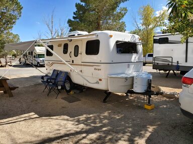 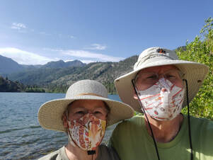 We stayed here because we had not seen the lakes here and wanted to use it partly as a convenient location for other side trip. For that purpose, it worked well. While we were there, the first day, we went for a short trip to Mammoth Lakes area. We had been there for a number of days five years ago. We were looking for an RV accessory and thought we might find it there, but no luck. We drove up the road past Mammoth Mountain ski resort, and continued to Minaret Vista, which looks over the Minaret peaks and the valley where Devils Postpile National Monument is. Because of the virus, the only access to the monument was using your own vehicle and it was full, so we just drive to the vista, which is a great little spot. After viewing Minaret Vista, we continued around the Mammoth Lakes Loop and the back to camp. The next day, we visited Bodie State Historic Park. It is a ghost town that was a very large gold mining town. A lot of the town burned in various fires, but there is still a core of buildings standing. The state keeps them standing but does nothing to change them from how they were abandoned. There were plenty of buildings and sites to see so it's probably good there isn't more still standing. We have heard about Bodie SHP mostly from weather reports as it is often the coldest location in the continental US while Death Valley NP is the hottest, and they are separated by just 200 miles - and about 8000 feet of elevation. 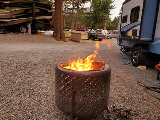 We stayed at Golden Pine RV Park which is between June Lake and Gull Lake. This is a small RV park and our site was just big enough for our 19 foot trailer. We had to park across the street for our Jeep. They seemed to take good care of the place. While we were there, they had 2 sewer backups which were serviced quickly, as quickly as they could get the plumber there. They had an overflowing trash dumpster, so they added a second one. At least we had a small fire pit so we could have our small fire and s'mores. Because it was so tightly spaced. it was noisy and crowded, and we won't be going back there.
This was our first stop on our US 395 trip. We drove from home across the Sierras and almost to Lake Tahoe, then headed south to Grover Hot Springs. The park has a really nice campground. We walked on a loop around the park which took us past the "hot springs" but since we were trying to be really careful about virus exposure, we bypassed sitting in the hot springs. I can't believe we spent two days there and the only photo I took was of the map of the state park! Actually, we drove around Lake Tahoe and I did take a few photos there when we stopped at a scenic outlook. This drive was memorable in that we drove south out of the lake and into a small part of Nevada where we were caught in a thunder and hail storm. Summer in the Sierras. |
Bill DornbushRetirement is great. We bought a travel trailer and are exploring National Parks. (Actually, we bought one and sold it and bought a second one better suited to us. It happens...) And I have time to do some woodworking projects and things around the house. And now I have gotten interested in ham radio so there goes any free time. ArchivesCategories |
 RSS Feed
Copyright © 2023 by Dornbush Web Design